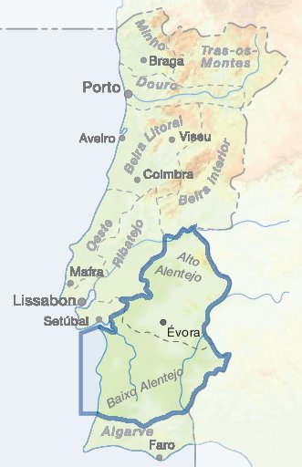
Locations
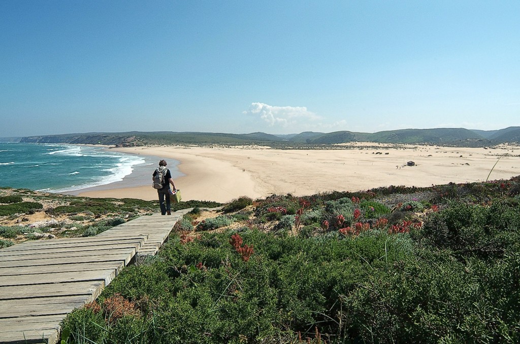
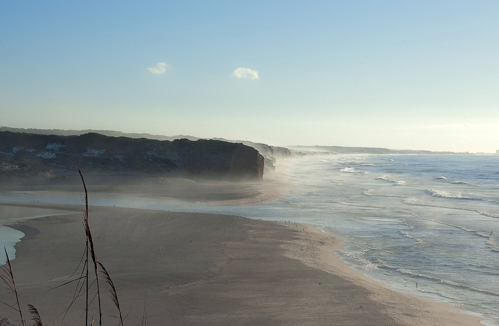
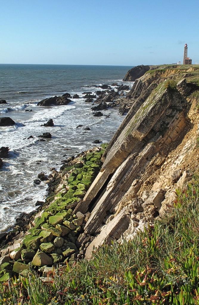
From Sagres, the coast turns north and you enter the most beautiful and unspoilt part of the Algarve coast with steep cliffs, small bays and impressive nature - one of the last paradises in Europe. In the 'wild west' of the Algarve, the wind blows stronger, the waves are higher, the temperatures are fresher and the forces of nature are stronger. You should at least make a day trip to this part of the Algarve to see the beaches at Vila do Bispo, the headland at Carrapateira, Praia do Amado and the beaches around Aljezur (Arrifana, Monte Clérigo, Amoreira). Individualists, nature lovers and also many drop-outs are drawn to this area. In the high season, however, the peace and tranquillity are over. You will find a lot of young people who come to the coast to surf and chill out.
The Eastern Algarve is not yet strongly characterized by mass tourism. Beach lovers will find their place along the approximately 60 km long stretch of coastline.
Fuseta, often spelled Fuzeta in the old way, lies in the midst of lush fields and shiny white salt marshes, where - as in Tavira - salt is extracted using the ancient method: The sea water evaporates in large, very shallow basins, leaving a thick crust of salt.
From Portimão, take the road (N266) north for about 25 km through lush landscapes with fields and avenues. The mountain peak Fóia stretches almost 1000 m into the sky, which even carries a thin layer of ice on some winter days.
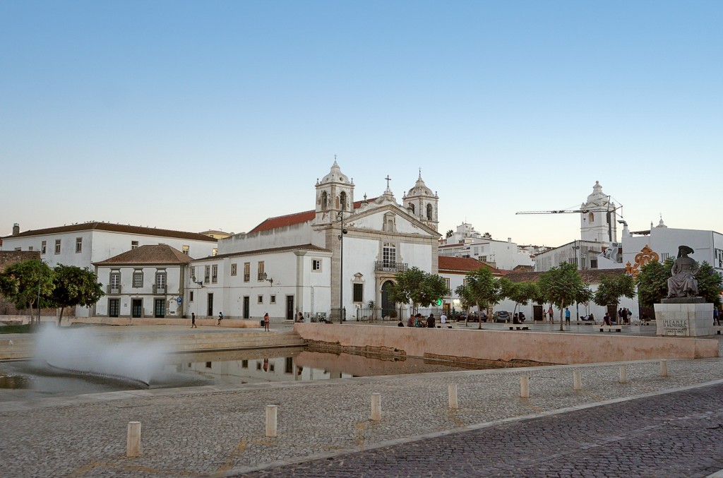
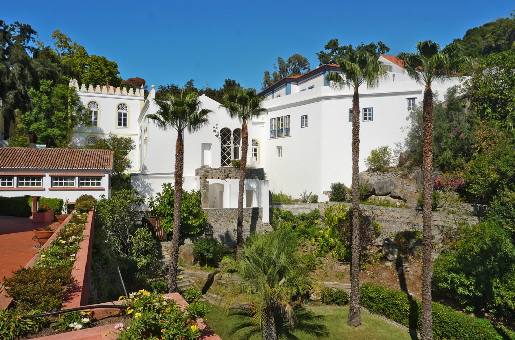
One of the oldest towns in the Algarve with a historic small-town atmosphere. The conditions for bathing and diving are optimal: you can choose between a long beach with dunes on the opposite side of the river and small rocky bays with crystal-clear water to the west of the town.
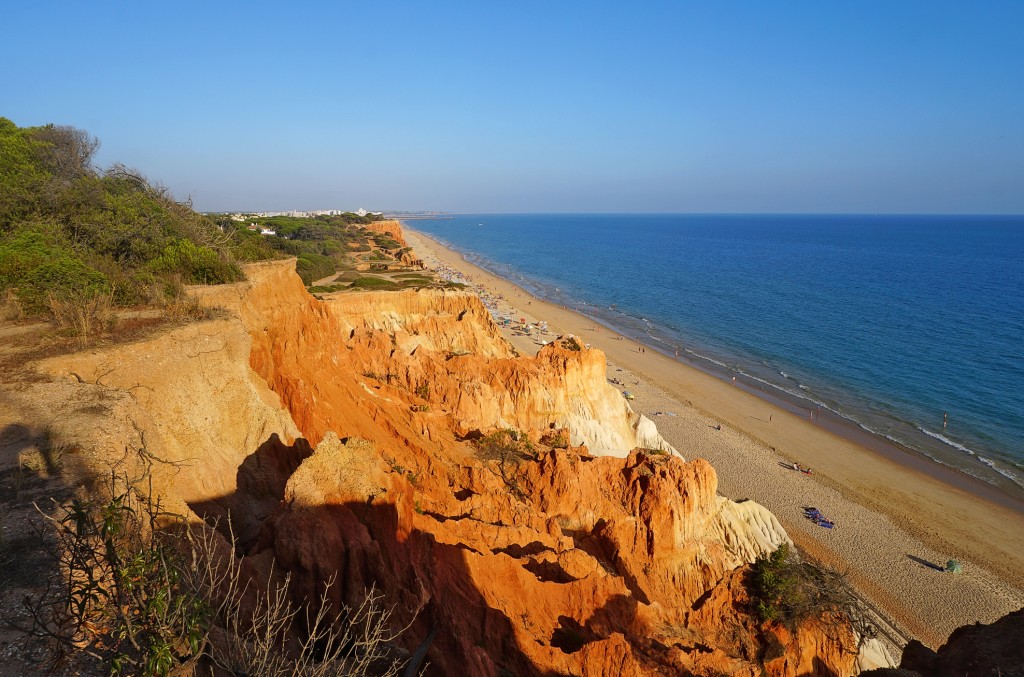
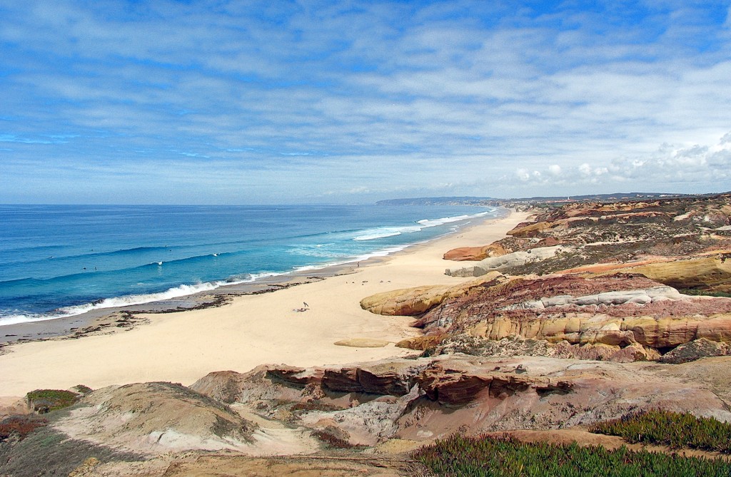
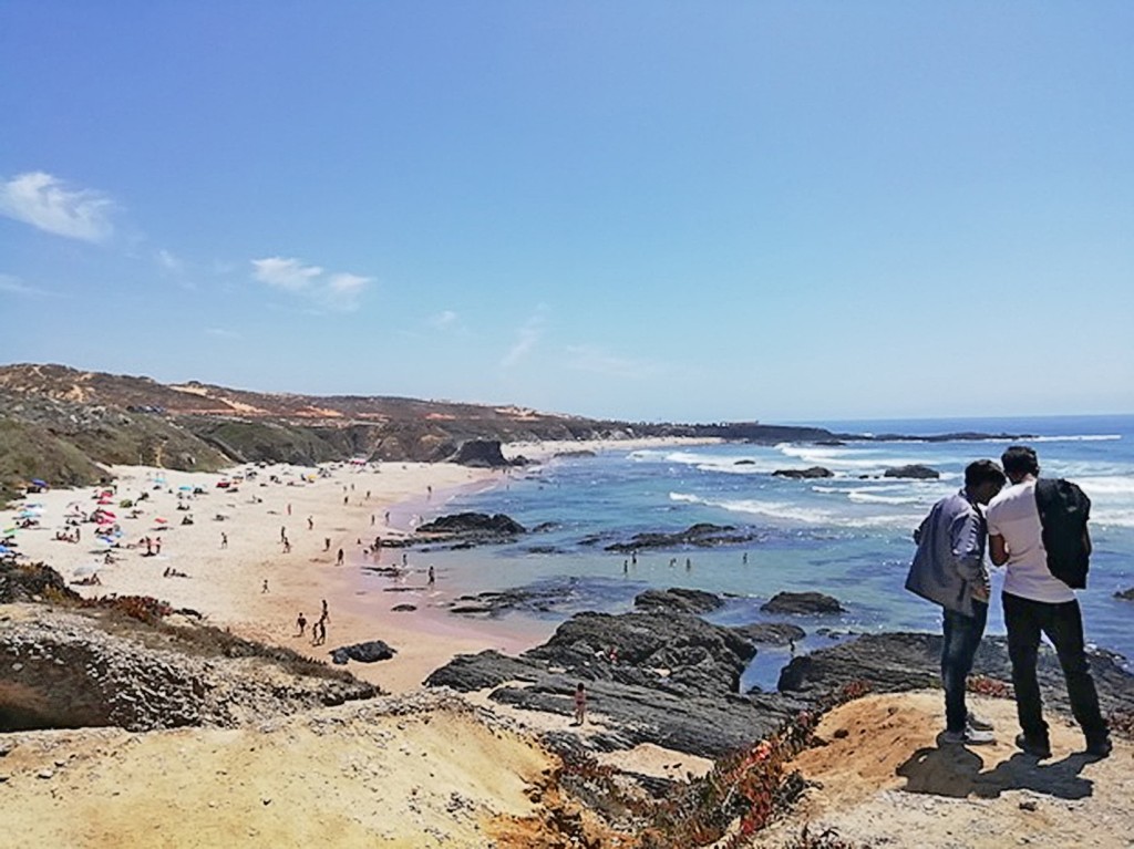
The epitome of a beach holiday in Portugal: In the west of the Algarve you will find typical beaches with red shining rocks, hidden bathing bays and cliffs dropping steeply into the sea.
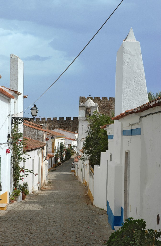
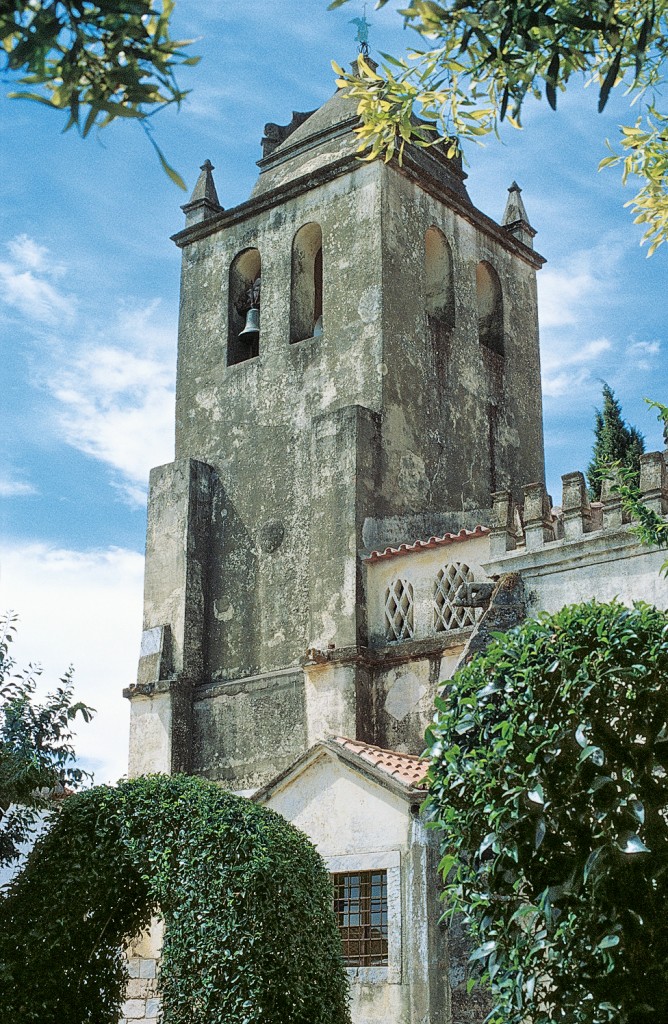
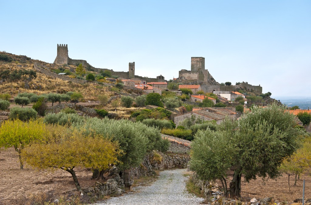
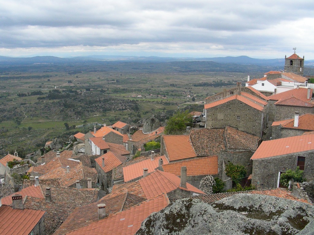
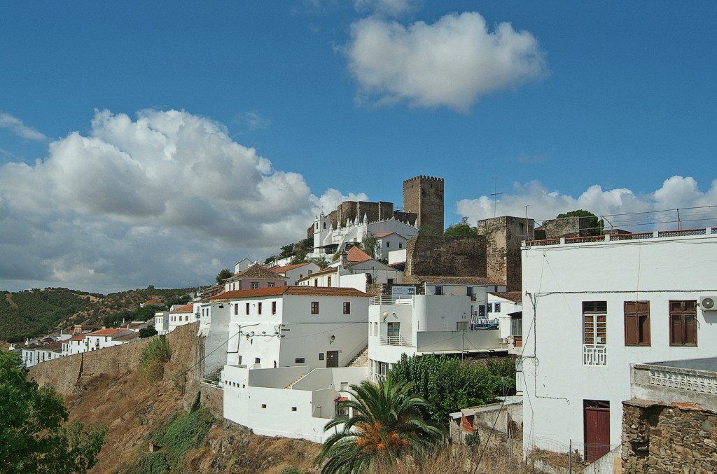
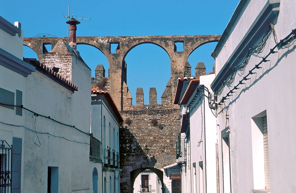
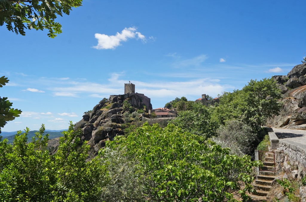
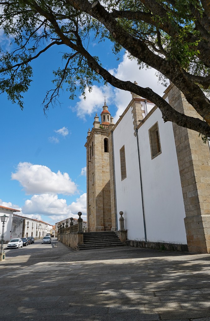
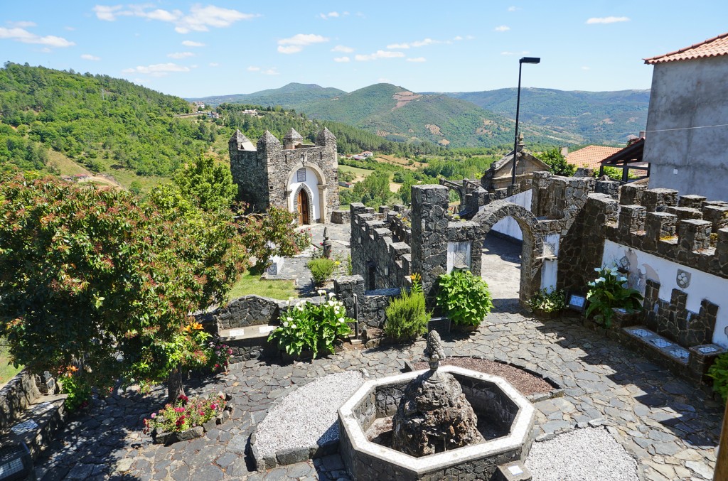
This typical village lies far off the beaten track. Its imposing castle from the 13th century, with the clock tower grafted onto the Torre de Menagem in 1774, looks almost a little Italian. Some of the castle walls are accessible. Unfortunately, however, one or two stones are missing. Inside the walls is the baroque Igreja da Nossa Senhora da Conceição (often locked, mass Sun 12 noon and Fri 7 pm, ask for key at Turismo). The old people meet around the Castelo under palm trees and at the marble fountain.
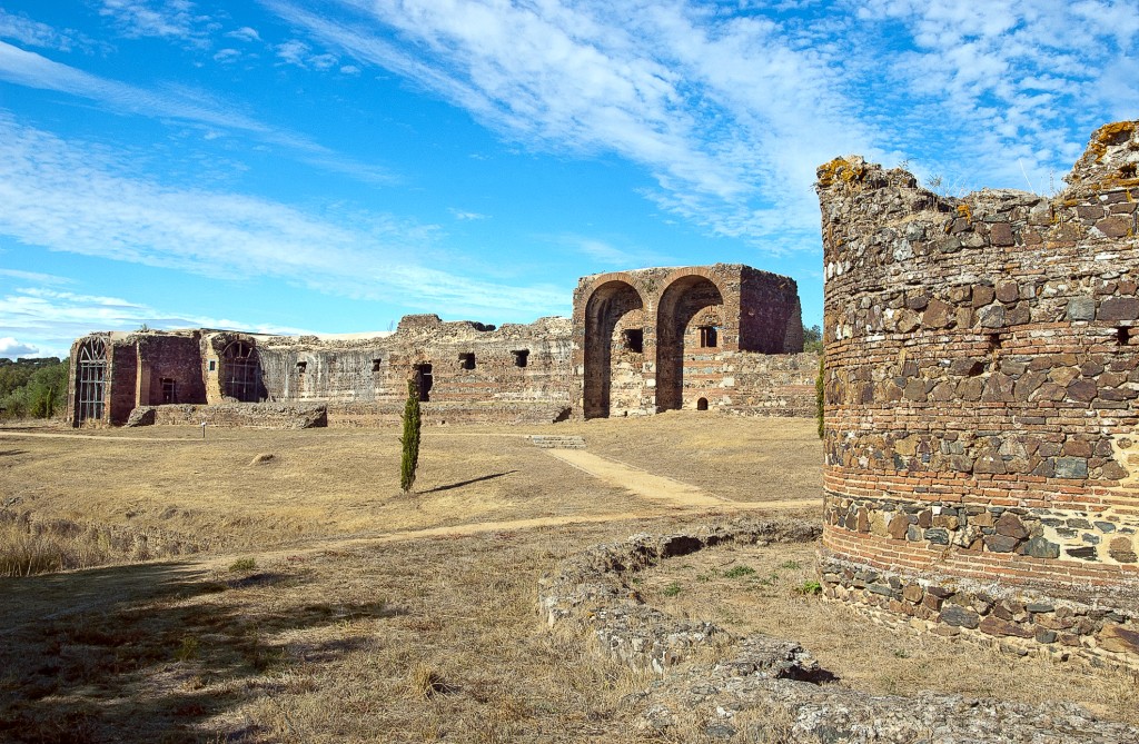
At the confluence of the Rio Alcoa and Rio Baça a monastery was founded in the Middle Ages that was to become one of the richest in Europe. It was founded on the occasion of the victory over the Moors by King Afonso Henriquesthe first Portuguese king, in 1153 and the current building was begun in 1178. Since 1989 the Monastery complex has been a UNESCO World Heritage Site.
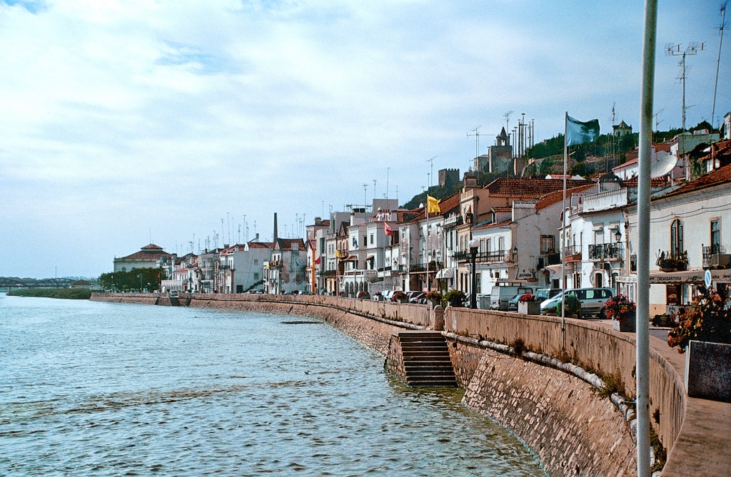
The ancient town nestles on a gentle mountainside, below which the Rio Sado widens into a huge estuary delta. Incidentally, the Roman-Arabic place name means nothing other than Salzburg. However, the extraction and sale of sea salt is no longer so important today. However, if you come here in September, you can still watch the salt harvest in full swing (after leaving the town in the direction of Troia, turn right, arrows point the way to Salina Batalha). The special location on an old traffic route from the Mediterranean to the Atlantic meant that the town played an important role even in Roman times; it minted its own coins and was subject to Roman town law.
In spring, the meadow flowers bloom like colorful carpets, in summer the heat is suffocating, in winter it almost freezes. Portugal's largest and most sparsely populated region is a land of contrasts.
Almeida is the largest of the historic towns - and probably the best-preserved fortress in Portugal. Almeida cannot really be described as either a village or a town. The historic, village part of the town is surrounded by an impressive, star-shaped fortress, which was built after the end of the personal union with Spain in the 17th century. A large housing estate has developed outside the defensive walls.
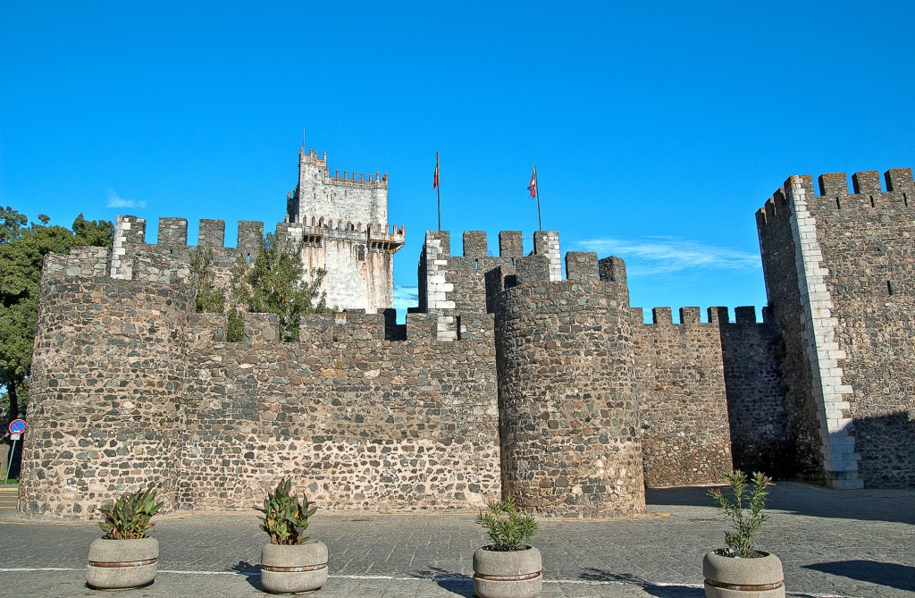
A visit to this typical village is well worth the detour - you can explore the castle palace, churches, historic old town houses and even two reservoirs in the surrounding area. The fortified palace from the end of the 15th century, now a pousada, with a square courtyard and corner towers is striking. Its special charm is due to Mudejar style elements such as the windows with horseshoe arches and the typical brick finishes. There are two huge cypress trees in the inner courtyard, where sparrows from the surrounding fields scurry about at sunset to find a place to sleep. It's a spectacle that you can enjoy over a meal in the pousada's restaurant, where you can feel ennobled, as this is where the title of baron was first awarded in Portugal in the 15th century.
The tranquil village lies at the foot of a castle that is more than 600 years old and offers a magnificent view from its walls. It is famous for its elaborately embroidered carpets, which have been produced here for more than 500 years. At the time, no palace in the country could do without wall decorations from Arraiolos and even today, many tradition-conscious Portuguese have at least a small one of these carpets in their homes.
Canals, salty mudflats and special light conditions characterize the atmosphere of the city. Aveiro is located directly on the lagoon and the five canals - Canal das Pirâmides, Canal de São Roque, Canal Central, Canal do Cõjo and Canal dos Santos Mártires - provide access to the old town for the boats of fishermen and seaweed fishermen.
Situated on the northern edge of the Serra da Arrábida in a beautiful hilly landscape, this small town with its rural character is ideal for a stopover between Sesimbra and Setúbal.
The village looks like a swallow's nest in the cliffs. The best view of the picturesque settlement high above the sea is from the viewing platform opposite, which is located on the road to the neighboring village of Praia das Maçãs.
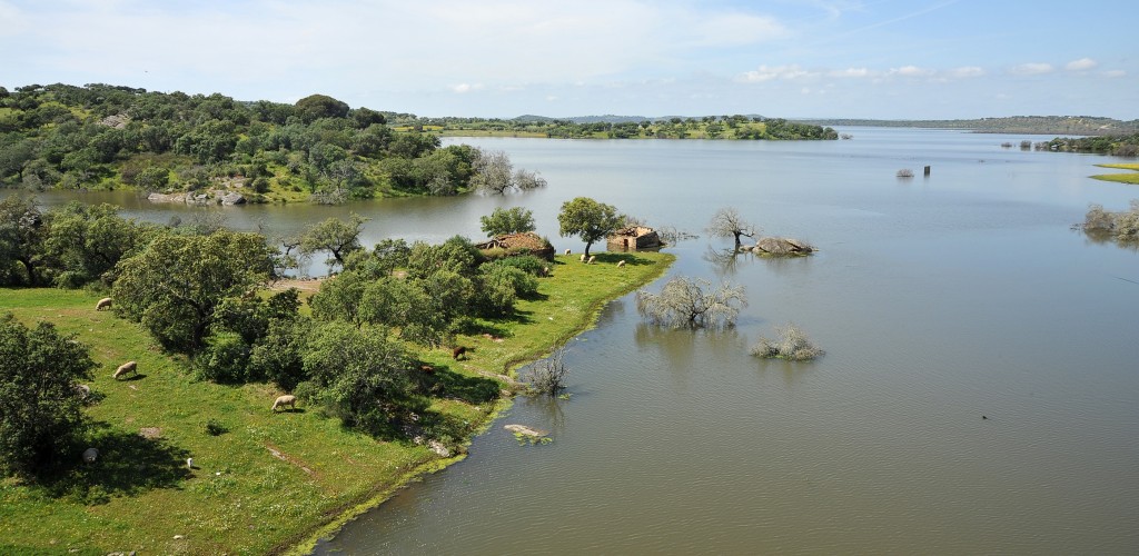
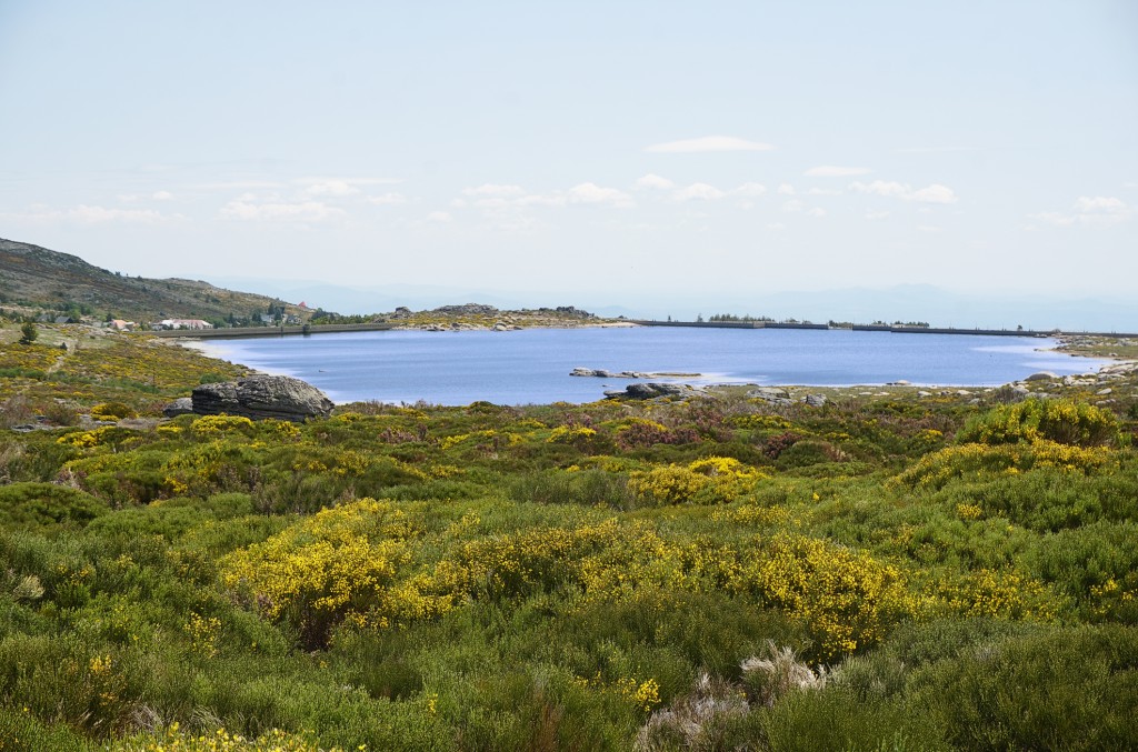
Europe's largest reservoir (250 km2, 63 km2 of which are on Spanish territory) has been flooding the valleys of the Baixo Alentenjos to the north-east of Alqueva since 2002. The Guadiana was dammed over a length of 83 km with a maximum water level of 152 m above sea level. Because the lake is very rugged, 1100 km of shoreline have been created. The plans date back to the time of the dictatorship and were taken up again after the Carnation Revolution. The primary aim was to boost agriculture in the arid Alentejo with an ingenious irrigation system and thus help the desperately poor region to get back on its feet. Under the motto 'Sea of 1000 Possibilities', it was also hoped that this would give a significant boost to tourism. Boat moorings and artificial beaches were built and the surrounding villages were to be turned into tourist resorts. Investors were dreaming of building hotel complexes or retirement villages for northern Europeans, and even music nights on the lake were already being planned.
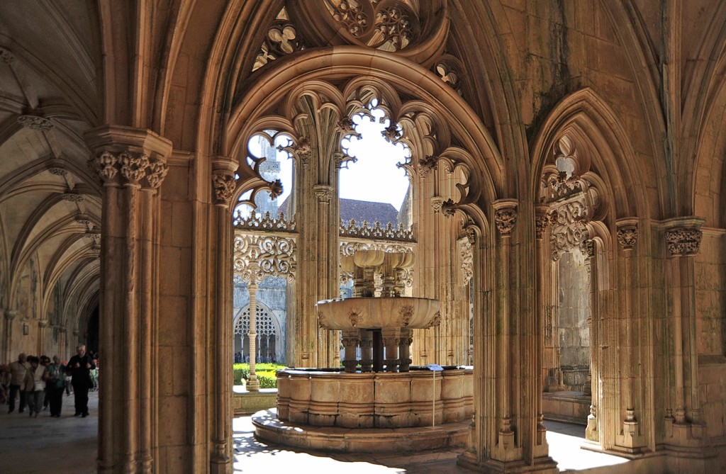
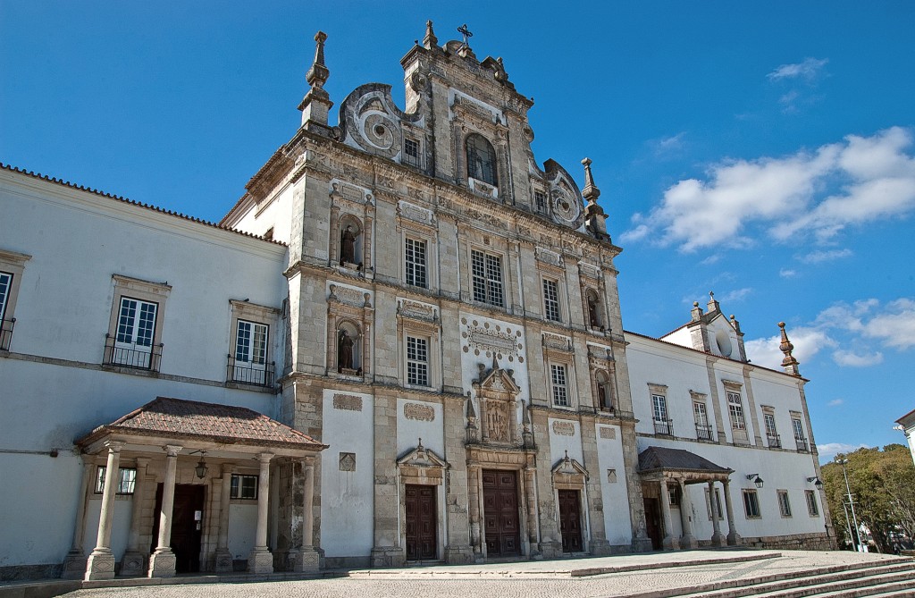
The place with the largest monastery complex in the country. It took around a century and a half to build the Gothic-Manueline style buildings. The monastery is a symbol of Portuguese independence and was built after the Battle of Aljubarrota.
Beja is the capital of the largest district and yet is a little sleepy in the vastness of the Alentejo. No less historic than Évora and offering a number of sights within walking distance of the center, it nevertheless appears modest and untouristic.

Belém is a friendly district on the Tagus estuary, approx. 7 km from the center of Lisbon. It was from Belém that Portuguese explorers set off on their sea voyages, such as Vasco da Gama to India in 1497. In addition to plenty of greenery in well-tended parks, Belém is home to Lisbon's most remarkable building: the Jerónimos Monastery. It is a huge building in the playful Manueline style from the Age of Discovery. Not far away is the old harbor fortress Torre de Belém in the same architectural style. The modern cultural center Centro Cultural de Belém with Portugal's most famous collection of modern art is located between the two historic buildings. The country's president also resides in Belém in the Palácio de Belém. There are also many interesting museums to discover, such as the Archaeology Museum, the Carriage Museum and the Naval Museum.
Known for its thermal baths, the town is now more worth a visit for its museums and park. Caldas da Rainha developed into a center of Portuguese art and handicrafts in the 20th century.
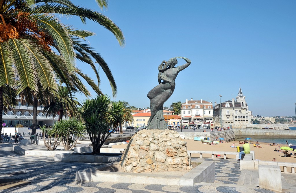
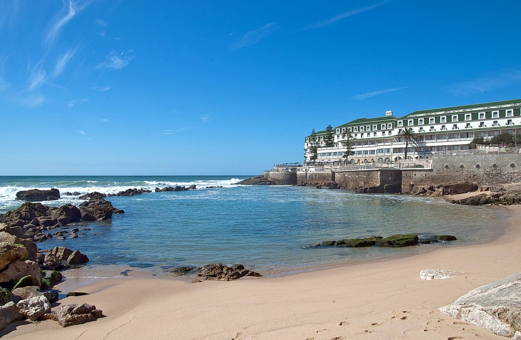
The town on a rocky coastline only offers small sandy bays from time to time. Cascais used to be a fisherman's nest, but today it offers idiosyncratic contrasts: colorfully painted fishing boats anchor in the harbor next to modern aluminum ships, old stately villas line the streets and apartment buildings rise up in the background.
The district capital of Beira Baixa is located deep in the interior. Surprisingly, Castelo Branco seems to have been somewhat spared the usual rural exodus and ageing of the Beira Interior, and the town appears lively and active.
A historic mountain town with around 3100 inhabitants that invites you to take beautiful walks through flower-filled, medieval alleyways and small parks. King Pedro V. called it the 'Sintra of the Alentejo'. The town, at an altitude of 650 m, offers charming views of the surrounding countryside.
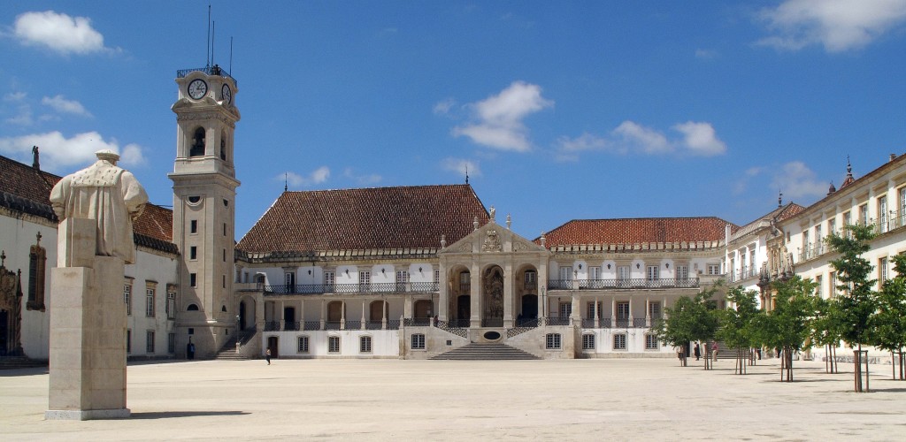
The oldest university city in the country - together with Lisbon - offers a wealth of sights. In addition to interesting churches and beautiful parks, there is also an impressive library. Thanks to around 35,000 students, the city is lively and relaxed.
Anyone strolling through the narrow alleyways and enjoying the flowering plants that reach out from windowsills and gardens can hardly imagine that the great Portuguese poet Luís Vaz de Camões is said to have spent two years in exile here, allegedly because of improper love for a lady-in-waiting.
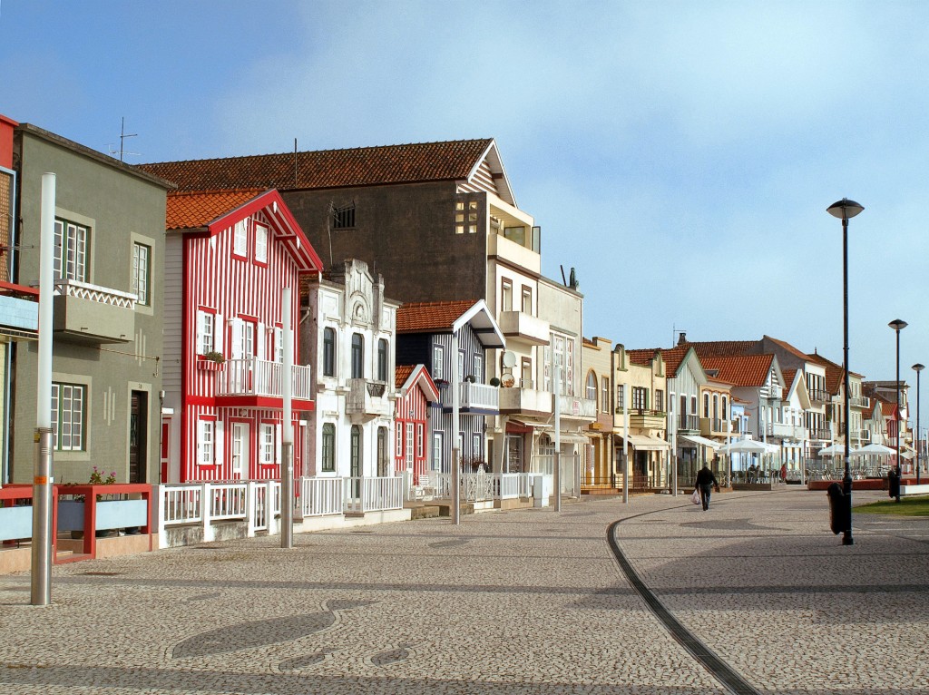
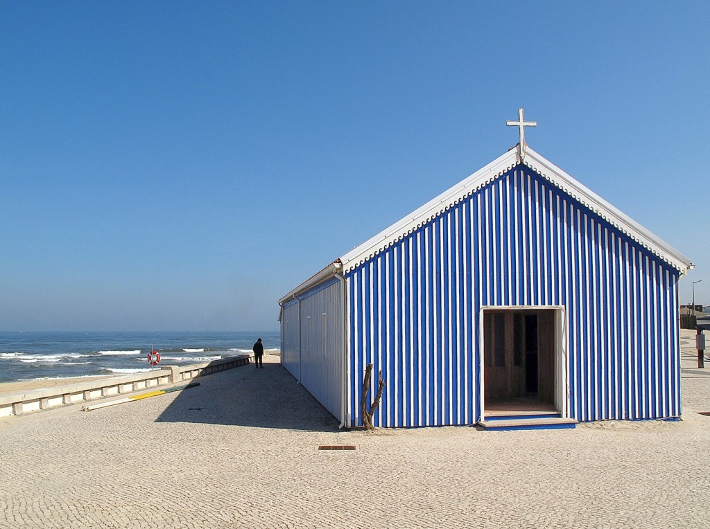
Here you will find the small wooden houses and villas in the 'striped suit' that are not missing in any Portugal brochure.
Inconspicuous, typically rural Alentejan town with a name from Arab times (coba = small tower, wine barrel). Whitewashed little houses are lined up close together in narrow, deserted streets. Only a look behind the facades makes Cuba interesting.
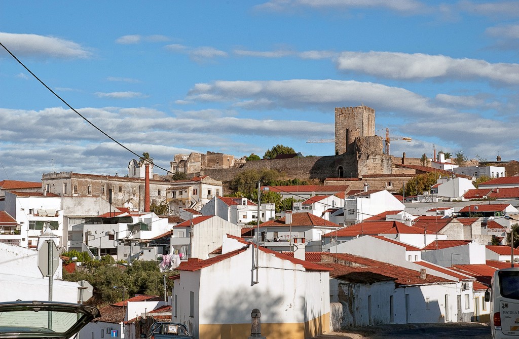
The very fortified small town on the Spanish border rests in the wide, soft landscape of the Alto Alentejo, but was often the target of clashes, first between Moors and Christians under King Afonso Henriques, then between Spaniards and Portuguese.
The small town 40 km northwest of Lisbon is a popular beach destination. Ericeira has a particularly glamorous name among surfers - some of the best surfing beaches in Europe are located here.
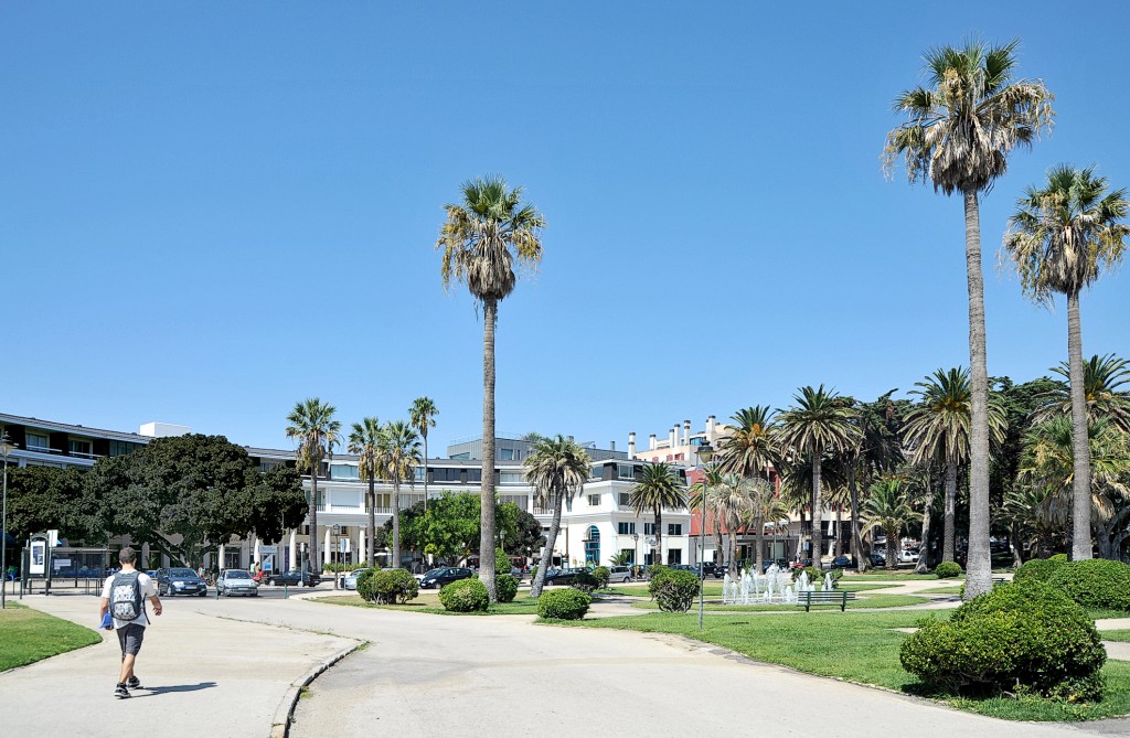
Estoril is a seaside resort with lots of greenery and luxury, several upscale hotels and luxury villas from the 1930s. The 'Lisbon Costa do Sol' became famous as the summer residence of abdicated kings.
Almada is Lisbon's neighboring city on the south side of the Tagus. It was once the center of Portuguese shipbuilding. However, the shipbuilding industry in Portugal has repeatedly experienced severe crises, and today tankers are no longer serviced in Almada. What remains is the gigantic 300-ton steel portal of the former Lisnave dry dock facility.
The seaside resort on the Costa da Prata lies in a green landscape at the mouth of the Rio Mondego. Only a few old villas still stand on the promenade between 10 to 15-storey apartment buildings. However, the center is still dominated by buildings from the 18th and 19th centuries.
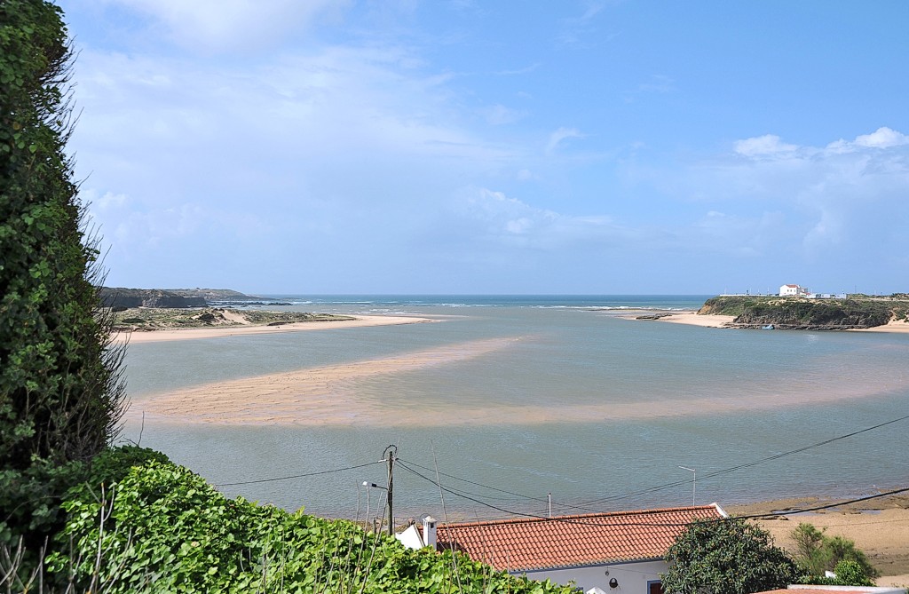
A dream of a beach! Swimming is possible in a lagoon, which is refreshed with sea water at high tide, as well as in the sea. The only drawback of the beach is the lack of shade. The lagoon is up to approx. 5 m deep. In August, the water can reach 25 °C. Locals go hunting for mussels in the lagoon to pick up starters for dinner.
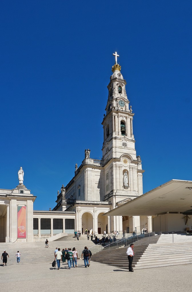
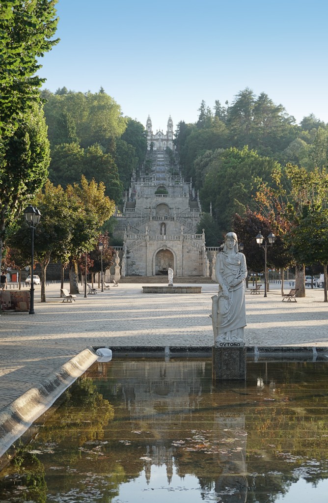
When you hear the name Fátima, you think first and foremost of the pilgrimage site, the basilica and the huge square in the adjacent Cova da Iria. For Portugal, it is the holiest town and, after Lourdes, the most important Catholic Marian pilgrimage site.
'The automobile is a passing phenomenon. I believe in the horse,' predicted Germany's last emperor, Wilhelm II. In Golegã, the self-proclaimed horse capital, the residents share his view. Nothing works here without a horse. Even the hairdressers declare their allegiance to horses with the emblem above their door signs. Golegã is the home of the Portuguese Lusitano horse breed. Once a year, in November, the national horse market, the Feira de São Martinho, takes place here: Thousands of visitors flock through the streets, traditionally dressed cavaleiros ride through the town and horses and riders demonstrate their skills in dressage and show jumping competitions on the large picadeiro. The hustle and bustle is accompanied by exhibition openings, book launches and many events. The region's chefs also demonstrate their skills, with the scent of chestnuts wafting through the streets in keeping with the season.
A quiet village on the edge of the Serra da Estrela. Gouveia is known for its lovingly tended gardens and parks, and the medieval town center is also well preserved. However, since the turn of the millennium, the population has fallen by almost a third because many textile factories in the region have had to close - many young people have moved away. There is a market in the market building every Thursday. A few old looms are operated on the ground floor for those interested. These demonstrate the pre-industrial trade.
José Afonso sang about the typical rural town as a 'vila morena' (brown town); he was thinking of harvested fields and the reddish-brown soil. His song was the revolutionary starting signal that was broadcast on the radio on the morning of April 25, 1974. And so, right at the northern entrance to the whitewashed city with its beautiful squares, city parks, markets and old townhouses, you come across the unmissable monument to the victory over the Salazar dictatorship.
Portugal's highest city rests on a massive granite block in the middle of the barren highlands of the Beira Alta1075 meters above sea level on the north-western side of the Serra da Estrela. Today, it is mainly visitors from neighboring Spain who come here.
The Alfama is the oldest district in Lisbon, where many houses survived the 1755 earthquake almost unscathed. Due to the narrow alleyways, which are somewhat reminiscent of an old Arab quarter, the wrought-iron balconies are so close to each other that you could kiss your neighbor. During the festivals in June, the streets are decorated with garlands and the balconies with lanterns. Almost every courtyard and every square becomes a street restaurant, and the smell of grilled sardines and red wine fills the air. In recent years, however, the district has been heavily gentrified and around 50% of the apartments are now rented out to tourists. Many people who originally lived in Alfama have now moved to other districts.
The Baixa, Lisbon's traditional business and banking district, stretches between Rossio and Praça do Comércio on the banks of the Rio Tejo. The authentically preserved streets, all straight and at right angles, were designed on the drawing board after the devastating earthquake of 1755. The Chiado is the intellectual quarter of the 19th century with its opera house and numerous theaters. It extends above the Baixa.
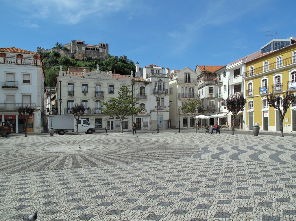
The Castelo of Leiria was only rebuilt in the 1920s and immediately catches the visitor's eye. And the district capital on the Banks of the Rio Lis also shows other beautiful sides.
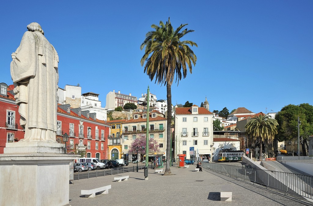
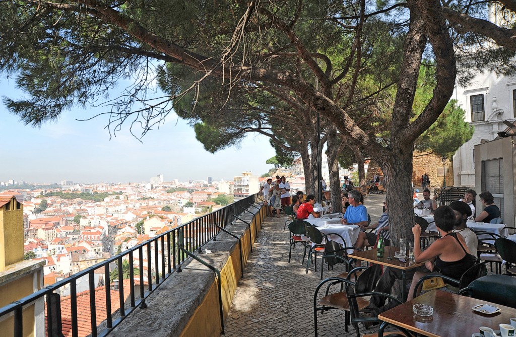
Lisbon rises on several hills above the wide estuary of the Rio Tejo and is considered one of the most beautiful European capitals. You should take at least three days to get a taste of the Lisbon atmosphere.
Lousã is located in the wooded, hilly Serra of the same name, 27 km south-east of Coimbra. The town still has a few pretty manor houses from the 17th and 18th centuries. The baroque Paços do Conselho, which houses the town hall, and the Capela da Misericórdia are also worth seeing, otherwise new buildings dominate the town, which gives an intact impression. There is a paper factory and a liqueur factory.
The Forest of Buçaco is a 105-hectare lush park that was first used by a monastery and later as a royal retreat and summer residence. Today it is a popular tourist attraction. In the castle you can stay in one of the most beautiful luxury hotels in in Portugal. The Luso thermal baths are located to the north of the park.
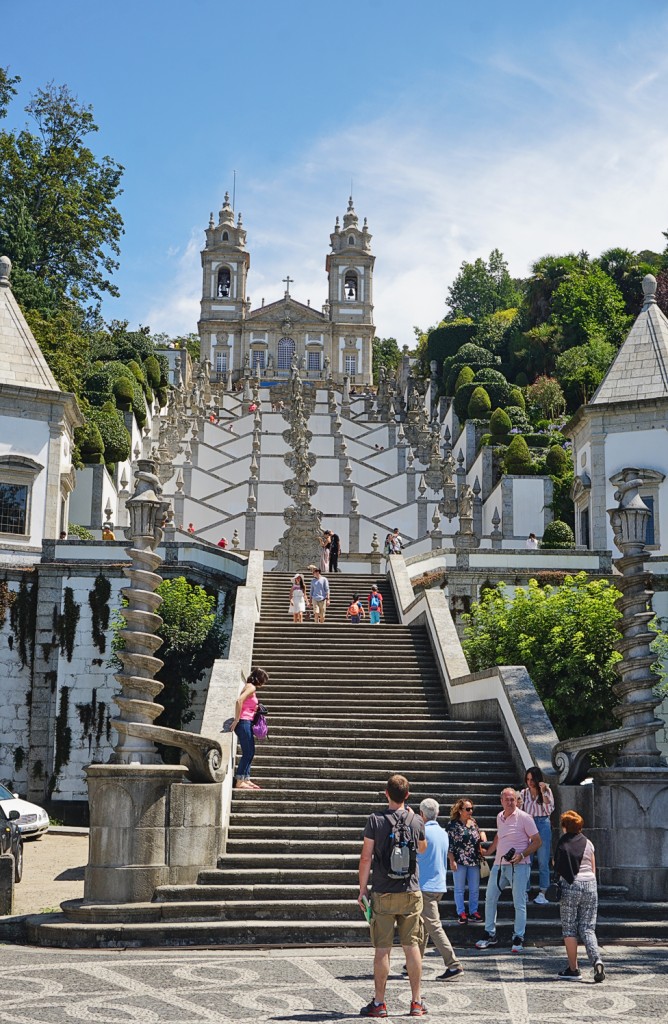
The small town in the north-west of Lisbon is dominated by the gigantic National Palace, visible from afar National Palace which is even larger than its Spanish counterpart, the El Escorial near Madrid. The monumental building is considered the most important work of Portuguese Baroque architecture, it houses one of the most beautiful libraries in the world and has been a UNESCO World Heritage Site since 2019.
Around 23 km south of Vila Nova de Foz Côa are the ruins of the castle in the small village of Marialva. The medieval walls are particularly fascinating at night when they are illuminated by floodlights and attract the attention of drivers on the nearby IP 2. The castle had its heyday in the 12th and 13th centuries, but today it looks more like a ghost town.
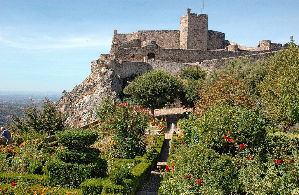
Marvão is enthroned at a dizzying height on rough, angular rock with its mighty castle complex, shielded by a city wall. it is rightly called the 'Eagle's Nest'. As you pass through the city gates, the present gives way to the Middle Ages. The ancient houses, the completely preserved town wall, the castle complex - everything contributes to this. You should not miss a visit to the Castelo de Marvão in the west of the city. Just behind the castle entrance on the right is the cistern, whose water surface reflects the vaulted, heavy stone ceiling and prevents you from seeing the bottom. The rocky hill on which the Castelo and the whole of Marvão were built ends in the castle courtyard. The entire complex is a masterpiece of fortress architecture and is in very good condition; the castle walls and the partly triple wall are accessible throughout. No matter from which point you look at the landscape, you will always come across a mosaic of rugged mountains, deep green conifers, illuminated by the bright sunlight or slightly dipped in the color of a strong evening red. From here, you can enjoy the wonderful view as far as Castelo Branco or the Serra de São Mamede.
The village was founded in 1938 by Propaganda Minister António Ferro as the 'most Portuguese village in Portugal'. The reason was certainly less the political attitude of its citizens than the typical architecture of the village. The granite houses huddle at the foot of huge boulders, which were already sacred to the Lusitanians. This is where the name Monsanto (sacred mountain) comes from.
The tiny castle village is perched on a hill and looks watchfully towards Spain and, since 2002, over the gigantic Alqueva dam. Small cobbled streets with whitewashed houses with a few restaurants, stores, cafés and some attractive accommodation lie within the castle walls. A few Lisbon and French artists maintain their summer residences here.
If you travel from Beja, you will be greeted by a large oil mill at the entrance to the village. This is where the harvest from the huge olive groves around the town ends up. The friendly district town with its impressive Moorish quarter is dominated by the ruins of a castle and monastery. Below it bubbles a thermal spring - Moura was also a spa town.
The small town, overlooked by an elongated castle 6 km from the Spanish border, is now better connected to the Portuguese world thanks to the huge bridge following the construction of the Alqueva dam, but its immediate location on one of Europe's largest reservoirs has changed it completely.
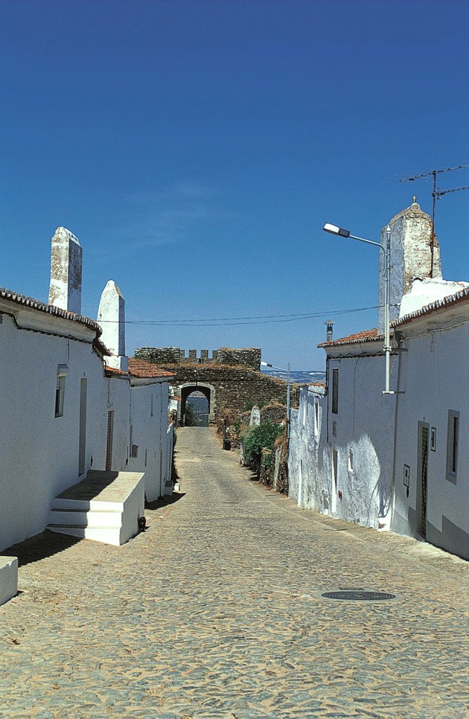
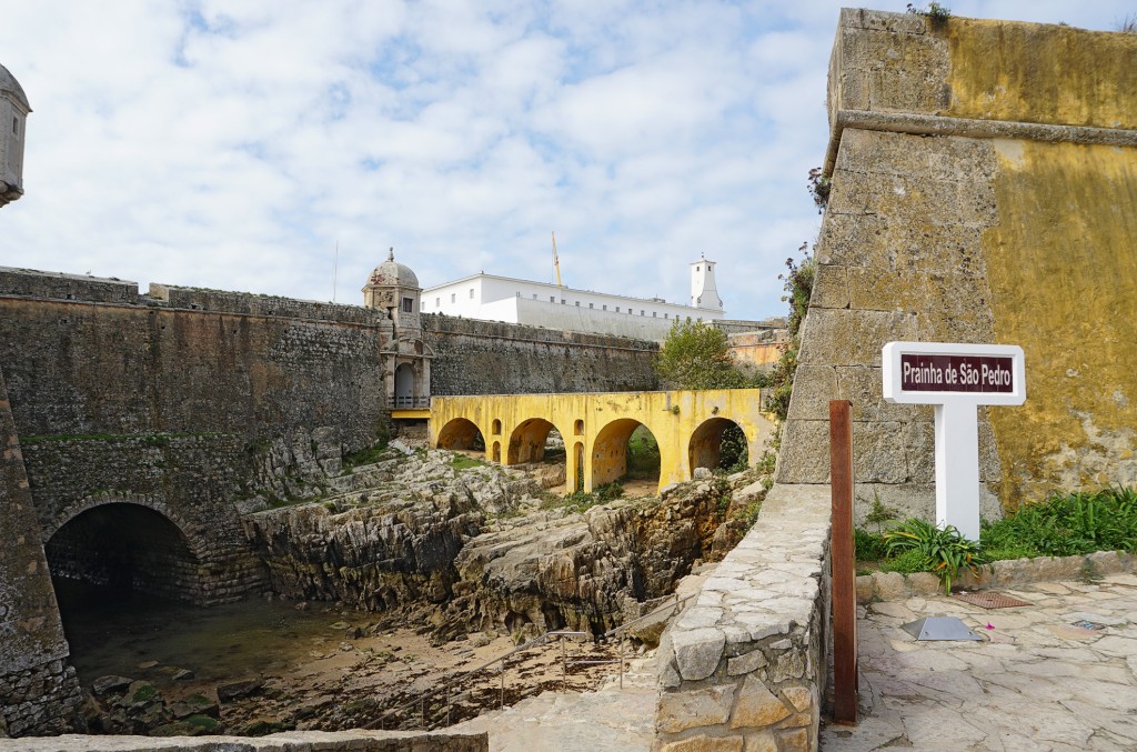
The Oeiras river flows here into the deep Rio Guadiana, which is still influenced by the tides. The old fortress and the small town sit enthroned on the steep hill, protected on the land side by a ring of walls. Portugal's best-preserved Moorish town is a unique backdrop for the Moorish Festival, which takes place every two years.
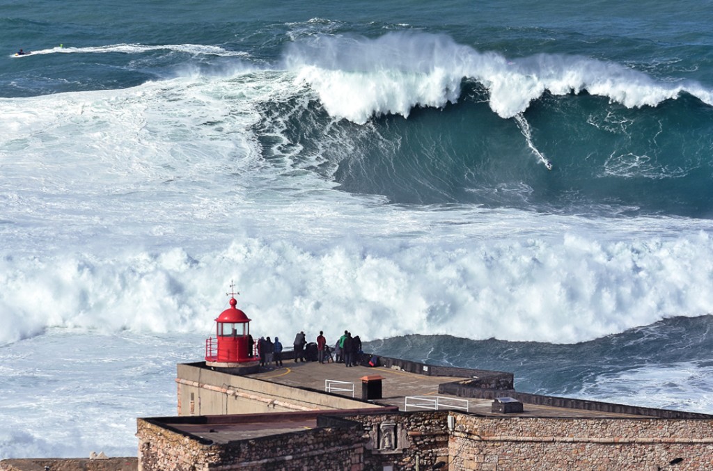
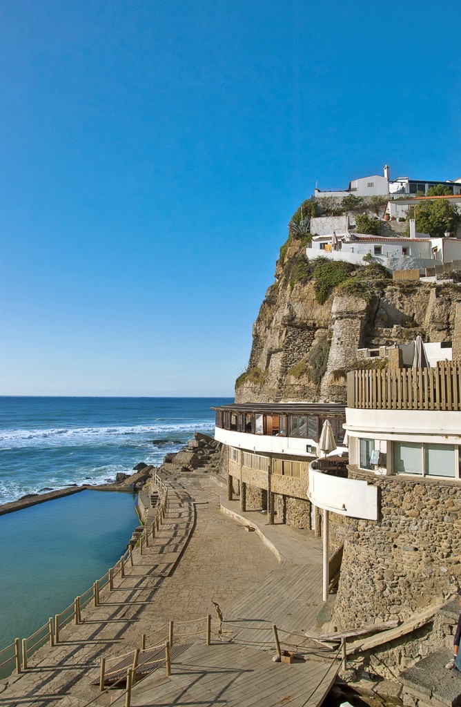
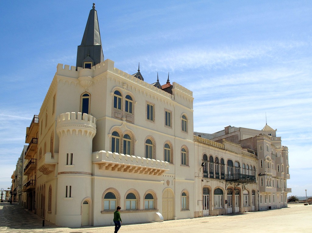
The country's most famous fishing village lies at the end of a long sandy bay, just below a huge cliff standing in the sea. The fishermen, who were still mending their nets between the boats until the 1980s, were famous for their traditional costume: flapping trousers and thick-fabric slip shirts with a tartan pattern. Today, only the fishermen's wives who fish for tourists at the stalls still wear this outfit.
A pretty little town with narrow streets and a tiny main square - Odeceixe already belongs to the province of Algarve. There are a few stores and tascas, as well as a few guesthouses. The impressive beach is about 3 km outside, directly below a small collection of mostly older summer houses, which look like a pretty village ensemble. A small river (the Seixe) also flows into the sea here.
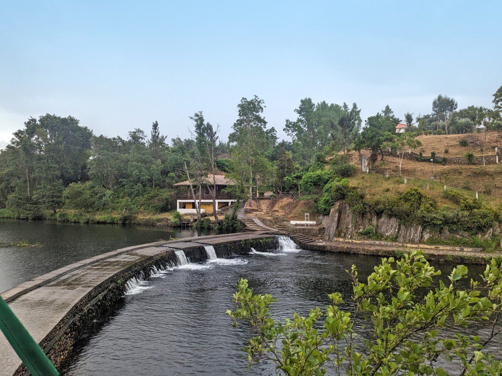
The sleepy inland town is dominated by the Rio Mira and lies on the edge of the nature park. The best view is from the former castle hill. It ends in a promontory with steep sides, where there is still an open-air stage (in the form of a small amphitheater) and the paved promenade Cerro do Peguinho. You can also enjoy a wonderful view from the intact windmill, where grain is still milled in the old way. The friendly windmiller is happy to show you how it works. When he is there is written on the notice at the mill.
On the steep mountainside above the Rio Mondego in the middle of a green, wooded landscape, the view over the valley is fabulous. The river offers opportunities for swimming, fishing and canoe trips. According to the tourist office, the water quality has been certified with the Blue Flag (praia fluvial) can be found on site. Penacova is located approx. 23 km northeast of Coimbra and 20 km south of Luso.
The bustling fishing town is located on a flat, rocky peninsula, which is shielded from the mainland by an old fortification wall with a moat. The important fishing port is also the starting point for excursions to the rocky Berlenga Islands. Beautiful beaches in the surrounding area.
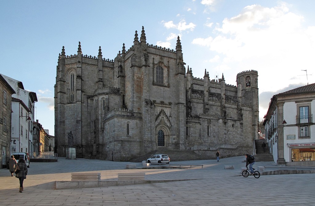
You should plan at least one stop in the district capital, because in the old town center you can stroll through narrow alleyways past pretty patrician houses (17th/18th century) to the towering 16th century cathedral. The real history of the city began with Jorge de Melo. He was to become Bishop of Guarda in 1549, but as a local patriot he ensured that his home town became the bishop's seat. City rights followed, as did noble houses and a Jesuit college, which the Marquês de Pombal had dissolved in the 18th century. He set up a textile factory there, from which the tapestry factory emerged in the 20th century. In addition to the carpet museum, some of the carpets and tapestries for which Portalegre is famous can already be seen in the Museu Municipal next to the cathedral. However, the museum's collection is dedicated to sacred art. The exhibition on the veneration of Santo António, who came from Lisbon and not Padua, is interesting.
The village was only founded in the 19th century when the small natural harbor was expanded in order to transport the ores mined at Cercal; this is where the strict, chessboard-like plan of the complex comes from. Low rows of houses and the tranquil village square Largo Marquês do Pombal dominate this first larger seaside resort south of Sines, which is already located in the natural park. There has been and still is building activity on the eastern edge of the village. Many Portuguese have their vacation homes in the low terraced houses. The landscape is rather gentle, the vegetation sparse (grass, heather) and the coastal cliffs are low.
One of the most beautiful beaches in the country is packed with bathers, and not just in August. There is also noisy entertainment on the beach. There are lakes, a lagoon and a long sandy beach in the surrounding area. On the beach, the wooden Capela da Praia de Mira catches the eye; holy mass is still sometimes celebrated in this 140-year-old place of worship.
The province in the plain of the Rio Tejo is characterized by extensive orchards and rice fields that stretch from the riverbanks far into the countryside. In the meantime, however, sunflowers have often replaced rice in the fields. Houses on stilts bear witness to the times when the Tagus still regularly poured out of its bed into the countryside.
The city stretches over a hill, 108 m above the meanders of the Tagus. The Moors built a protective castle on its highest point. Santarém is home to a number of beautiful Gothic churches, which is why it is also known as the 'Gothic capital of Portugal'.
The town with the Christian-Moorish name stretches between several hills. From the castle and parish church at an altitude of 254 m, there is a good view over the sea and the surrounding area. The important Roman ruins of Miróbriga can be seen on the opposite hill with a working windmill.
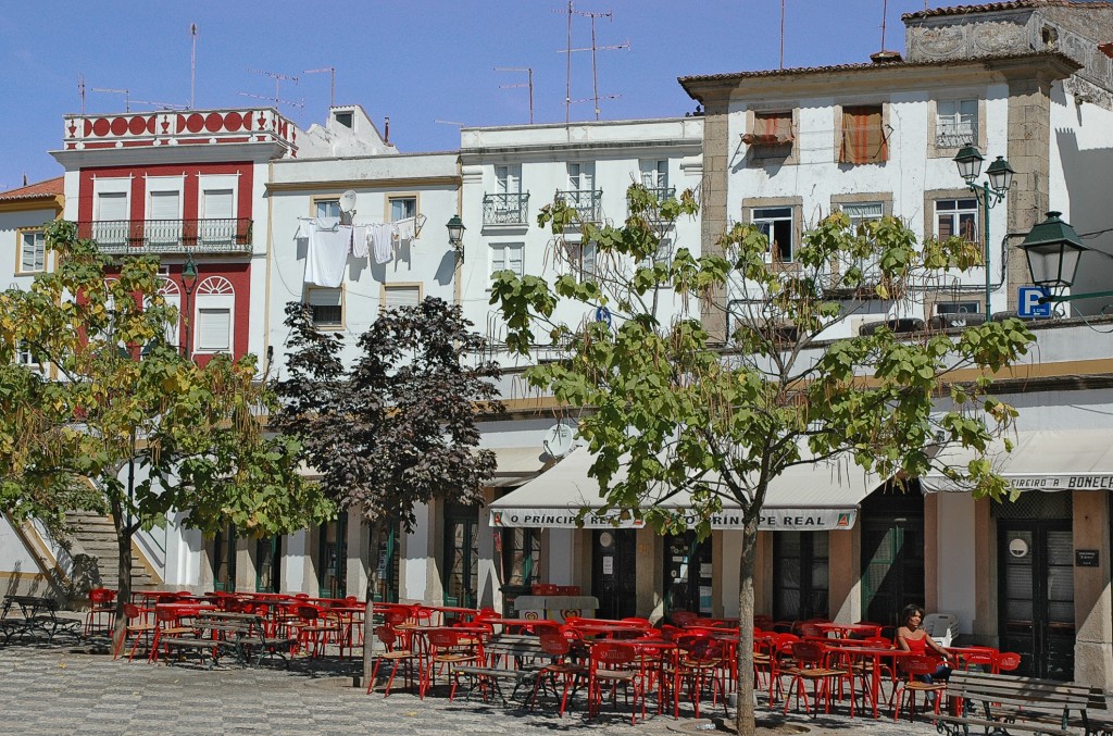
In addition to the many museums and the beautiful town center, the locals are also proud of their songs, cheese and good wine and make a trip here worthwhile. The annual 'competition for the whitest house' means that the facades are regularly painted. The town impresses with its many unconventional buildings - from the manor houses of the large landowners to the popular, simple town house - and its Alentejan way of life.
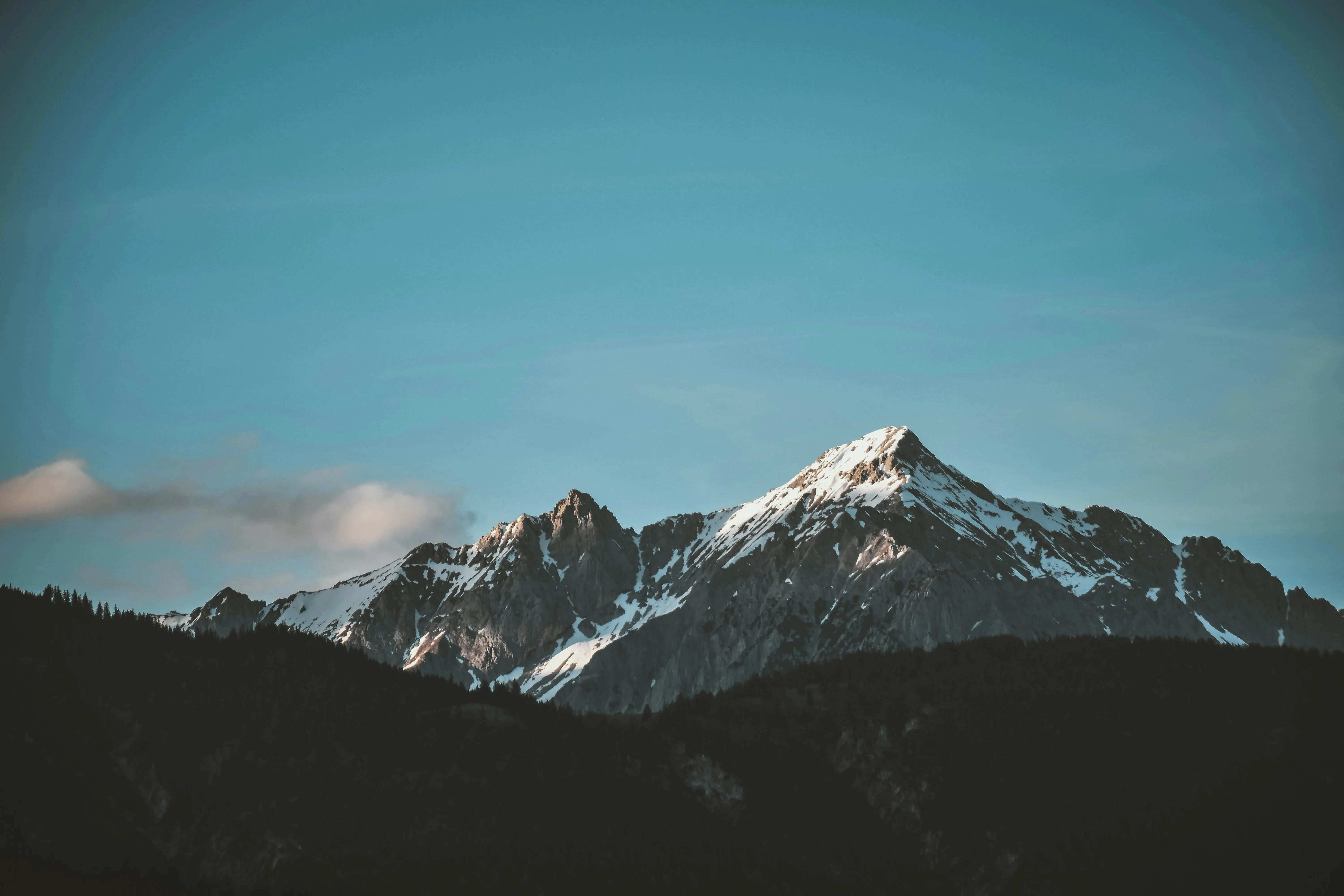
The Serra da Estrela is the highest mountain range in Portugal and the country's only winter sports region - it reaches almost 2000 m above sea level. However, the ski slopes cannot be compared with those in the Alps. The vegetation limit begins at around 1000 m. From this altitude upwards, the area is very barren and inaccessible, but beautifully pristine.
Setúbal is located around 30 km south of Lisbon at the mouth of the Rio Sado, protected by the Tróia peninsula. In addition to the pretty old town, the cityscape is characterized by unadorned apartment blocks in the outer districts and industrial plants along the Sado and the port.
The birthplace of the Indian explorer Vasco da Gama was once an attractive place for fishermen and sailors. Today, the remnants of the past are dramatically obscured by modern Sines, which has developed a world-class industrial port - and is constantly adding one hall or another.
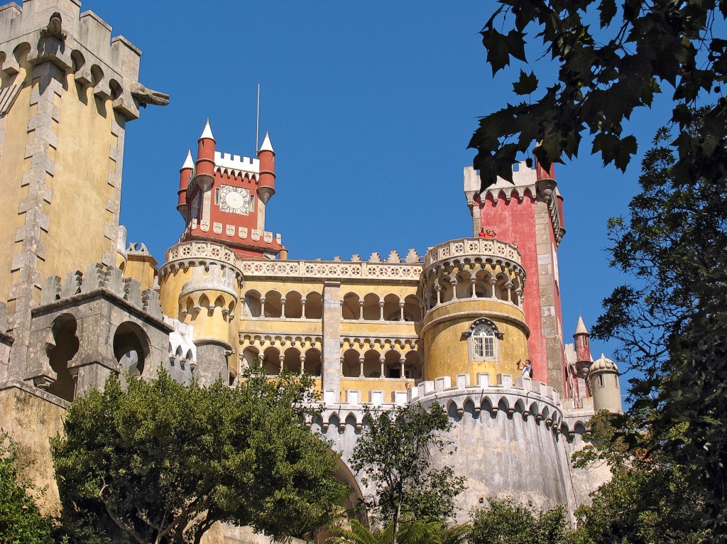
Around the heart of the city, the former royal palace Palácio Nacional, numerous beautiful palaces were built for the aristocracy, who preferred the cool Sintra to the hot Lisbon summer. Since 1995, the old town and the northern slope of the Sintra Mountains have been a UNESCO World Heritage Site. There and at the palaces, Sintra is a 'must' for most Lisbon tourists.
About 20 km from Belmonte, Sortelha is hidden between granite rocks in the mountains. The houses, streets and walls of the 1187 by Dom Sancho I. in 1187 are also built of granite. Before entering the historic center through the town gate, the view falls on the rock formation below the Torre de Menagem keep. The beijo eterno (eternal kiss) consists of two rocks whose tips gently touch.
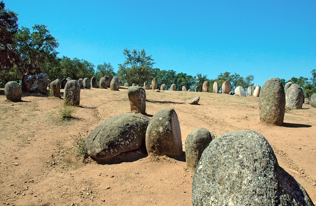
Cromeleque dos Almendres (Guadalupe): There are around 170 Stone Age cult sites in the agricultural areas around Évora. Probably the largest and oldest in Europe is the Cromeleque dos Almendres, half an hour's drive from Évora. It is estimated to be 5000-6000 years old - making it more than 1000 years older than Stonehenge in England, but far less visited. The stone circle originally consisted of over 100 monoliths, making it the largest collection of menhirs on the Iberian Peninsula and one of the most important sites in Europe. The cult site was created in two phases, first a small circle, later a concentric ellipse. Some stones are marked with symbols to which magical effects are attributed. Among other things, they are said to be able to boost fertility. Nearby is the 'grande menír dos Almendres', a large phallic symbol.
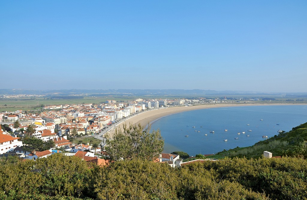
Concha - the shell - is the name given to the shell-shaped bay where São Martinho do Porto is located. It used to be the vacation resort of Lisbon's high society. The old town center is located slightly higher up on the cliffs, and the difference in altitude can now be easily overcome with the elevator at Turismo. Unfortunately, more and more dreary apartment buildings have been built on the bay in recent years.
The well-kept, mature village on the Atlantic coast is miraculously still surrounded on all sides by a thin strip of forest. The statues of King D. Dinis and his wife D. Isabel at the entrance to São Pedro de Moel, to whom we owe the preservation and expansion of the pine forest in the 14th century, seem to have stopped the major fire of 2017. The small bay and the side slopes are dominated by the summer houses of Portuguese city dwellers. A number of them are gems of Portuguese modernism from the 1950s; they were designed by famous architects inspired by Bauhaus or Le Corbusier. To the north, a small coastal road leads over the cliffs to the lighthouse (open Wed 14-17, in winter 13.30-16.30). In between are steep cliffs, followed by sandy beaches dotted with boulders. Cyclists have their own paths that lead along the Atlantic and to Marinha Grande.
The thermal springs around 26 km northwest of Viseu have been a place of healing and relaxation for more than 2000 years. Even the Romans appreciated the effects of the 68.7 °C hot springs, whose water helps with rheumatic complaints, respiratory diseases and is used in rehabilitation measures.
If you have the time and inclination, you should explore the neighborhoods to the west of the Bairro Alto. The district of Madragoa with its beautiful old town alleyways, which is a popular nightlife district with bars and restaurants, as well as Lisbon's most aristocratic district: the Lapa.
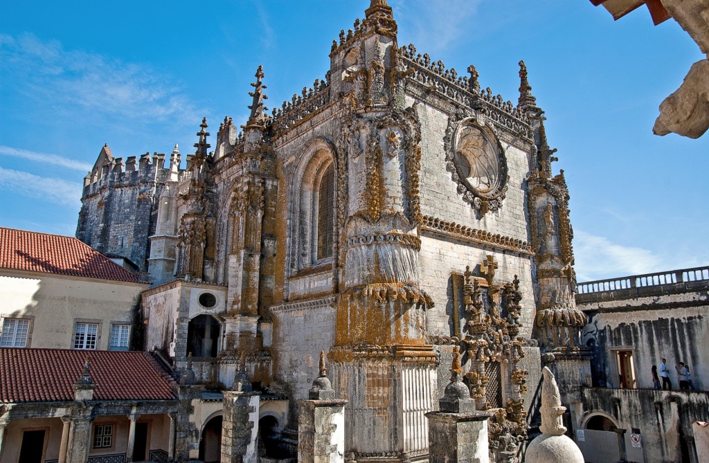
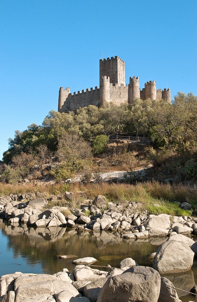
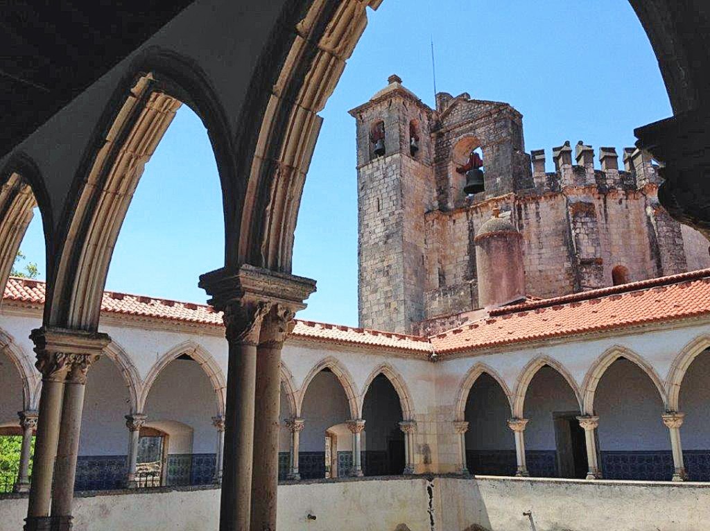
The town rises on a small hill through which the River Nabão winds. The mighty Castelo dos Templários e Convento de Cristo sits enthroned on the pine-covered hill above Tomar. The monastery is a UNESCO World Heritage Site and a correspondingly large number of tourists visit the town.
Many terraced houses with apartments line the long, straight streets that connect the Atlantic and the Ria. Most of them are only inhabited during the summer months, making the town seem deserted even during the week in August. At the weekend, water rats flock to the glistening sandy beach.
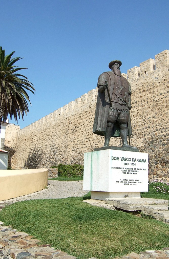
Vidigueira is considered the city of Vasco da Gamawho was born in Sines but was crowned viceroy after discovering the sea route to India and was given a noble seat here. Its keep can still be seen today on the hill above the town. The bell in the clock tower was donated to the town by Da Gama in 1520.
The small town is picturesquely situated on the wide estuary of the Rio Mira and offers beautiful beaches in all directions. For a few years now, an increasing number of young Portuguese and hikers on the Rota Vicentina have been stopping here and taking the boat across to the other side of the river.
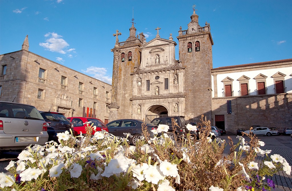
The town has a very well-preserved old town center and lots of greenery in the streets and squares. Viseu lies in the middle of a vast plateau. The massif of five mountain ranges towers in the distance.
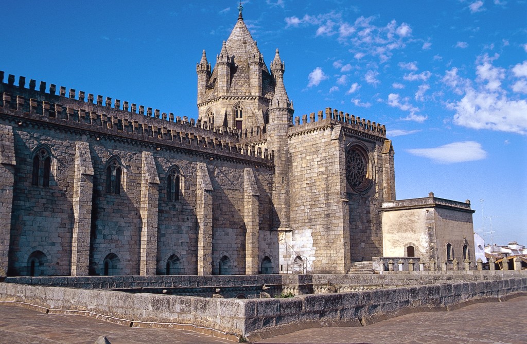
Surrounded by a 14th century wall, the city's historic center is rich in 16th and 17th century bourgeois houses, churches, palaces, squares and a temple from Roman times. Today, Évora is a UNESCO World Heritage Site.
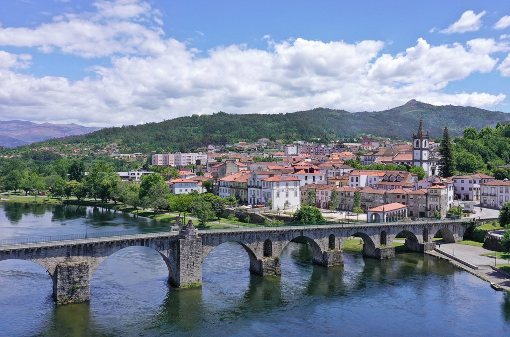
Besides the Rio Minho, which forms the northern border with Spain, the Rio Lima, which crosses the border from Spain at Lindoso in the Peneda-Gerês National Park, forms one of the most beautiful river landscapes of northern Portugal. The area is not overcrowded in any way, has some beautiful cycling routes along the shore and with Ponte de Lima a wonderful place to stay.
This little picture-book town in the far north of Portugal has a pretty, intact old town with narrow streets and a high fortified tower enclosed by a ring of walls.
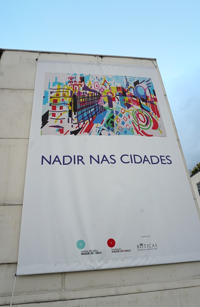
The village of 1,540 inhabitants, located 23 km west of Chaves, is known for its 'vinho dos mortos' ('wine of the dead'). This bottled wine was once created by chance: farmers buried their wine supply in the 19th century to hide it from the French soldiers. When the bottles were dug up again, the farmers were surprised to find that the wine was better than ever. This developed into the specialty that is popular today. You can buy this fine wine at the Turismo (one bottle approx. €10). The tourist information centre is also a spacious, light-flooded art exhibition, mainly with works by Nadir Afonso (see also at Chaves).
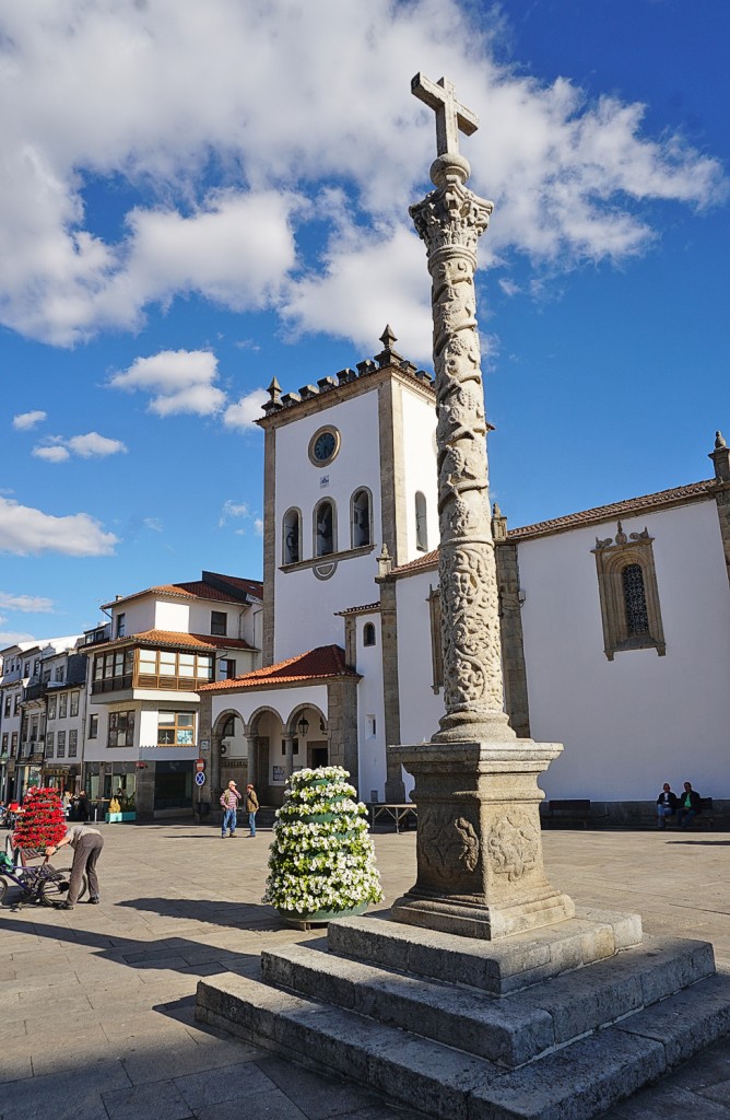
Bragança is the largest city in the Trás-os-Montes region, but how underdeveloped the area is is evident in the lack of industrial districts that usually surround the larger cities of northern Portugal.
The friendly town with thermal baths on the banks of the Rio Tâmega is nestled in an extensive, fertile green valley depression that has provided rich yields since time immemorial. Chaves was located on the Roman road Braga - Astorga and was of great military strategic importance.
A nice district town above the Douro River, where the mountainside turns into the Montemuro Mountains. Portugal's first king, Afonso Henriques (1139-85), went to school here with his tutor Egas Moniz. Another son of the city is General Serpa Pinto, who made a name for himself as an explorer of Africa in the 19th century and traversed the continent from the Atlantic to the Indian Ocean. A museum dedicated to him bears witness to his discoveries.
Freixo de Numão is a town steeped in history with settlement since the Copper Age (5000 BC). Accordingly, it boasts a large number of excavation sites. The Romans in particular have left their mark. A circular route leads through a breathtaking Douro landscape of vineyards, almond and olive groves to Prazo with its Roman and medieval ruins.
A beautiful coastal town sandwiched between wooded hills and the Rio Lima. The centre is the picturesque Praça da República, with a splashing fountain in the middle and richly decorated facades all around. The merchants' houses and the granite ashlar town hall were built during the Age of Discovery and reflect the wealth of that era.
A detour via the A 24 leads to the provincial centre of Lamego, located just south of the Douro Valley. The city calls itself the 'birthplace of Portugal' because it was here that the first king, Afonso Henriques, first summoned his Cortes.
The landscape is like its wine: green. The Rio Minho, which gave the province its name, is the border river between Spain (Galicia) and Portugal. Accordingly, you meet many Spaniards in the small places alongside the border.
A cathedral without a bishop, a language that is neither Portuguese nor Spanish, stick dancers like in Transylvania ... Miranda do Douro is a wild mix of interesting idiosyncrasies and at the same time a sleepy nest where the fox and the hare say goodnight to each other.
The 750 km² large nature park in the northeast is probably one of the most backward areas of the country. Especially to the north-east of Bragança, there are villages where time seems to have stood still, even in a negative sense: the rural exodus of the past decades has left many houses in some villages to decay. The remaining inhabitants do little for the preservation, much seems slightly neglected.
Leça da Palmeira: the northern section of the coast with the hamlet of Leça can be reached from Matosinhos via the Ponte móvel de Leça, a modern lift bridge over the Leça River. Here there are again wide sandy beaches with modern apartment development. Not far inland, you can still see the mighty installations of the Petrogal oil refinery, which ceased operations in 2021.
Portugal's only national park nestles right on the Spanish border and has everything you could want from such a park: lush vegetation, crystal-clear rivers, thundering waterfalls, refreshing swimming pools, rugged cliffs and, and, and. Especially on summer weekends, however, you are not alone, because then there are many excursionists from the nearby towns.
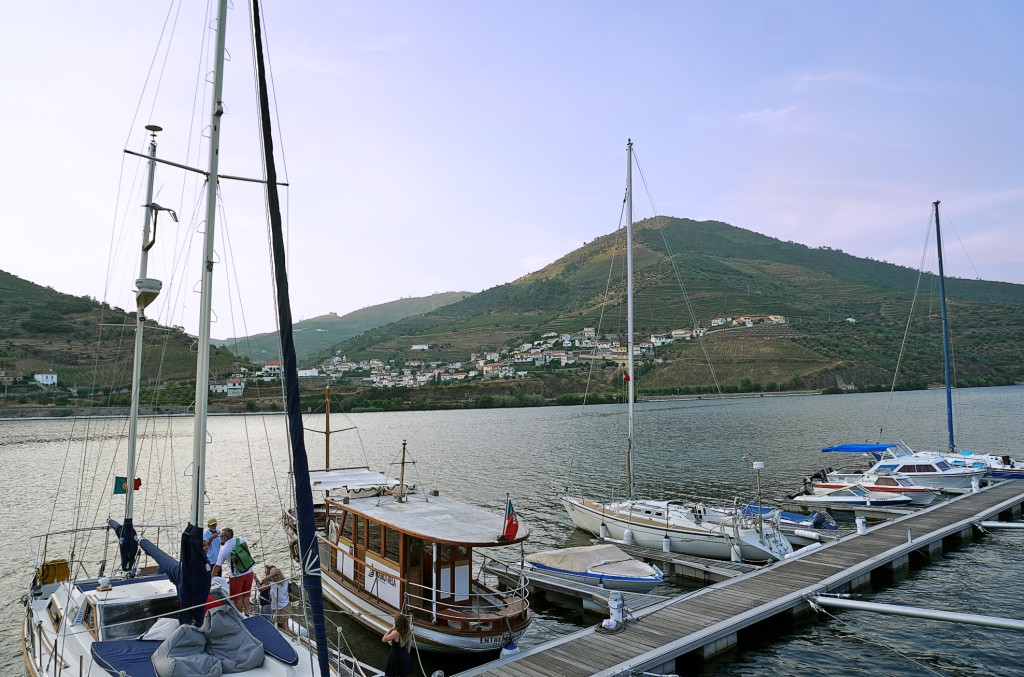
The last major town in the Douro Valley is the wine-growing centre of the region and a good starting point for exploring. The double name comes from the fact that there were originally two villages here, Régua on the river and Peso further up the valley slope. Both were united in the 19th century to form Peso da Régua.
Small sleepy village on the banks of the Douro. There are no sights worth mentioning, apart from the railway station decorated with azulejos (→ box) and the beautiful landscape.
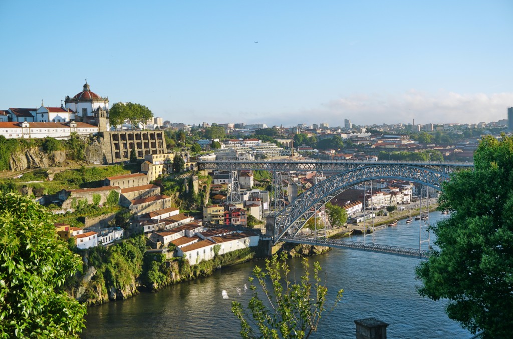
Porto's landmarks are the mighty steel skeleton bridge over the Douro, the Ponte Dom Luís I and the baroque church tower Torre dos Clérigos. The small medieval centre is dominated by the Cathedral and the huge Bishop's palace on the hill above. Only at one point, above the bridge, is the old town still surrounded by the city wall.
From São Bento station you can take the train in the direction of Ovar, after only 30 min. you will reach Miramar. From the train station there it is a short distance to the wide sandy beach. There you can see on the right the Capela do Senhor da Pedra, which was built photogenically on a rock in the sea. The place is said to have miraculous powers, and that is necessary: hoof-shaped imprints of the devil himself have been made out in the rock, and at night the incarnate is sometimes even said to prance around the capela.
The pretty town of 2,000 inhabitants with its old centre and narrow streets and surroundings is the heart of the Douro Valley. Its location on a plateau, some distance from the deeply cut Douro Valley, has enabled it to develop into a regional centre. Many newer buildings can be seen along the long thoroughfare of the village.
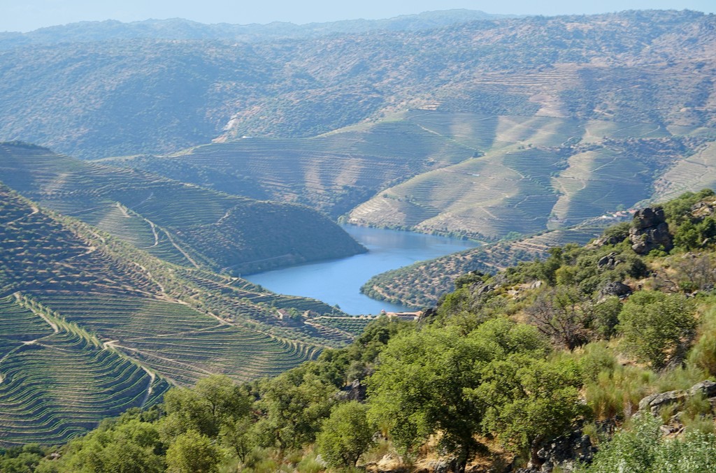
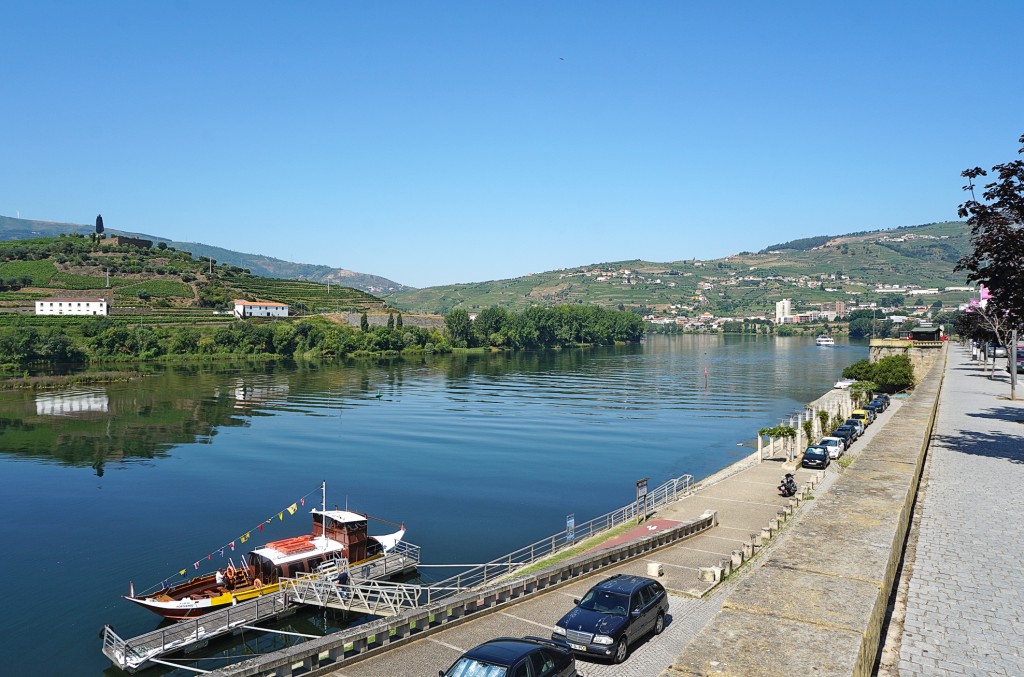
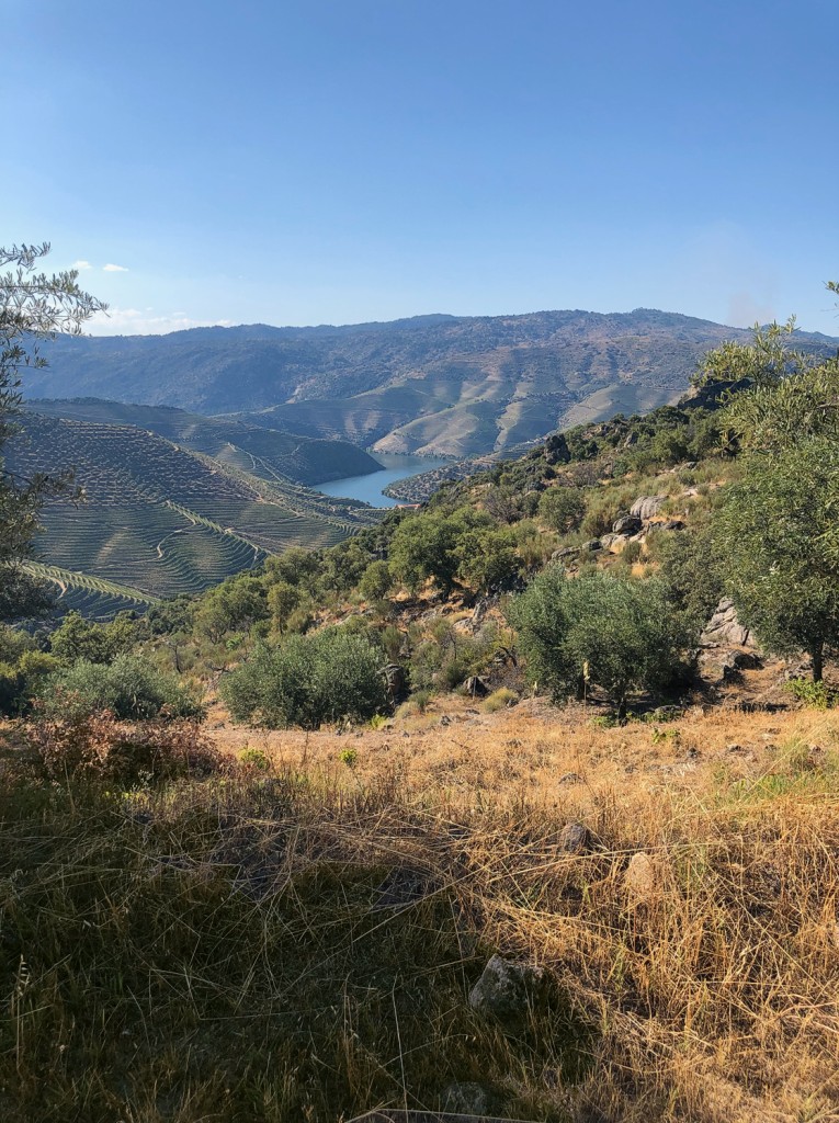
From Porto, the Rio Douro meanders through green mountains towards Spain. This is where the grapes from which wine is made grow. All along there are whitewashed villages.
The pleasant, somewhat sleepy mountain village of 2,800 inhabitants played a major economic role for centuries. On the local mountain, which rises next to the village, the most productive iron ore deposit in the country was discovered in the 19th century and exploited for a long time. In the beginning the ore was melted down on site, but it was soon more economical to transport the ore to Porto (Seixal) and smelt it there. In 1983, however, the mining company had to file for bankruptcy, and the Iron Age was over for Torre de Moncorvo. After long preparatory work, dismantling is now to begin again. Currently, viticulture is probably the most important economic pillar of the village.

'Beyond the mountains' is a barren landscape. The forests of the Minho and the endless vineyards of the Douro end here. The largest part of the Trás-os-Montes region is sparsely vegetated. The people are as rough as the landscape. Nowhere in Portugal, they say, do they curse as much as here.
With the discovery of the prehistoric carvings in 1992, the little town on the Douro experienced an upswing in tourism. Before the news about the Stone Age drawings was published in 1994/95, Vila Nova de Foz Côa was known for its almond blossom, its ageing population and the damming of the Rio Côa planned by the Portuguese power company EDP. But the discovery of the drawings, some of which are over 30,000 years old, forced the government to stop the dam project.
Vila Real is young. Although it has had city rights since 1289, it was only in the last 100 years that the small town at the confluence of the Rio Corgo and Rio Cabril grew to its present size. Accordingly, many buildings are also new, which does not necessarily enhance their beauty.
The elongated village is really 'behind the mountains', far away from the northern Portuguese metropolises, and on the Spanish side of the border there is also no bigger city that would provide a stream of visitors at least on weekends. But a lot of money was distributed by government agencies to make life in the community more attractive, reduce rural exodus and attract visitors.